Просмотр новости
Найдите то, что Вас интересует
 Спутники
 РН
РН SpaceX
 Роскосмос
 NASA
NASA
СпутникиРНSpaceXРоскосмосNASAMIAMI (VINnews) — Hurricane Isaias was on the cusp of major-hurricane strength Friday morning and was expected to come ashore along the northern Gulf Coast late Friday or early Saturday as a dangerous storm, the National Hurricane Center said. At 7 a.m. CDT, the center was about 245 miles south of Pensacola and about 170 […]
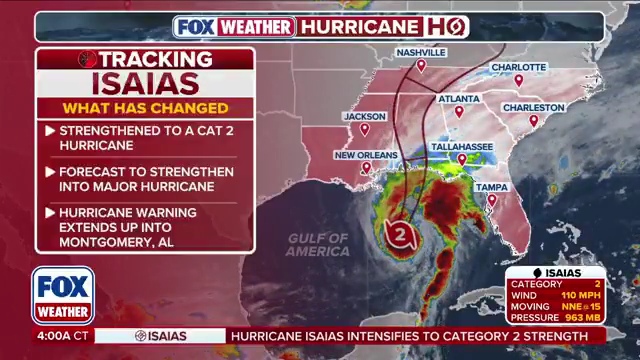
MIAMI (VINnews) — Hurricane Isaias was on the cusp of major-hurricane strength Friday morning and was expected to come ashore along the northern Gulf Coast late Friday or early Saturday as a dangerous storm, the National Hurricane Center said.
Subscribe to our Daily Roundup Email
At 7 a.m. CDT, the center was about 245 miles south of Pensacola and about 170 miles south-southeast of the mouth of the Mississippi River, moving north-northeast at 15 mph. Maximum sustained winds were near 110 mph, with a minimum central pressure of 958 millibars, based on data from an Air Force Reserve Hurricane Hunter aircraft.
https://vinnews.com/wp-content/uploads/2026/10/foxweather_360p_20261009_070328.mp4
Forecasters said Isaias was likely to become a Category 3 hurricane later Friday morning. Some weakening is expected before landfall, but the center said the storm should still be a dangerous hurricane when it reaches the coast tonight or early Saturday. Landfall is expected inside the hurricane warning area, with the greatest threat focused from coastal Mississippi through the western Florida Panhandle.
A hurricane warning was in effect from Ocean Springs, Mississippi, to the Bay/Gulf County line in Florida. A storm surge warning covered the coast from the mouth of the Mississippi River to the Suwannee River in Florida. Tropical storm warnings extended farther west into southeastern Louisiana.
The center urged residents in the surge and hurricane warning areas to finish preparations within the next few hours, saying conditions along the coast would deteriorate quickly. Life-threatening storm surge, damaging winds and flooding rain are the main hazards. Hurricane-force winds extended about 30 miles from the center, and tropical-storm-force winds reached out about 185 miles.
Rainfall of 4 to 8 inches is forecast from Friday through the weekend across southern Alabama, the Florida Panhandle and Big Bend, and southwest Georgia, with isolated amounts up to 10 inches. Forecasters warned of flash flooding, urban flooding and possible river flooding as the storm moves inland and weakens over the Southeast.
Florida Gov. Ron DeSantis has declared a state of emergency for 25 North Florida counties. Mandatory evacuations were already in effect for coastal areas of Okaloosa County. Officials across the warning area have told residents to follow local orders and leave if instructed to do so.
Isaias is the first hurricane of the 2026 Atlantic season. After landfall, gusty winds and heavy rain are expected to spread well inland across parts of Alabama, Georgia and the Southeast through the weekend.